Where We Have Been - NZ - Manawatū-Whanganui Region
We won the lottery just by being born—and getting to live—in a stunning part of New Zealand: Taranaki, with the majestic Mount Taranaki (Mount Egmont) presiding over everything. It’s one of those places where you really can ski on the mountain in the morning and finish the day watching the sun drop over world-class surf breaks in the afternoon.
We’ve explored pretty much all of our beautiful home country, from Cape Reinga in the far north to Milford Sound in the far south (David has even dived with the Great Whites off Stewart Island).
As we’ve travelled so widely around our home country, we’ll cover New Zealand region by region, sharing what we consider some of the highlights.

The Manawatū–Whanganui Region is one of those places people often drive through—but if you slow down a bit, it has some areas worth taking time to visit.
It stretches from the volcanic Central Plateau in the north right down to where it meets the Wellington Region. On the eastern side, the northern part of the region is separated from Hawke’s Bay by the big physical barrier of the Ruahine Forest Park, and further south the Tararua Forest Park does a similar job—running down and spilling into the Wellington Region as well.
Both ranges are serious country: rugged, often alpine in character, and not something you wander into on a whim. But for those who are properly prepared, they also open up a huge amount of tramping—wild, remote, and the kind of terrain that makes you really work for the experience, and in places the views, on offer.
South of Lake Taupō is National Park, home to Mt Ruapehu with its ski resorts, Tūroa and Whakapapa, as well as Mt Ngauruhoe and Mt Tongariro, all active volcanoes with multiple eruptions in the 21st century. This is also where you’ll find what’s often heralded as the best one-day trek in New Zealand—and frequently ranked among the world’s top single-day hikes—the Tongariro Alpine Crossing. Nestled on the slopes of Mt Ruapehu is the Chateau, which wouldn’t look out of place in the Swiss Alps. Access is via the road Kiwis refer to as the National Park Road, which if you are a rail buff, also puts you in the area of what is a significant engineering heritage site. The Raurimu Spiral is the solution to overcome what was at that time a challenging obstacle, a near 150m change in elevation on the North Island’s Main Trunk.
To the east of the mountains is the stretch known as the Desert Road, where the alpine Rangipo Desert is crossed by State Highway 1—kilometres of tarseal cutting through a stark, stunningly different landscape.

The Tongariro Alpine Crossing (don’t under estimate it)
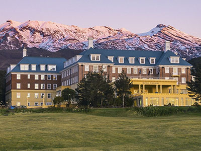
The Chateau with Mt Ruapehu

Rangipo Desert with Mt Ruapehu, Mt Ngauruhoe and Mt Tongariro
Waiouru, at the southern end of the Desert Road, is home to a major (by New Zealand standards) Army base. With the Rangipo Desert nearby, it also has a huge training area that’s used by New Zealand forces and visiting militaries. If military history is your thing, the National Army Museum is well worth a stop.

Image Coming Soon
Regardless of whether you’ve come over the National Park side or down the Desert Road, once you’re south of the Central Plateau you’ve got a choice. You can stay on SH1 and make steady time heading south… or you can turn west and “sneak” onto a slower, more interesting route that we’d pick every time if we’re not in a hurry: the River Road.
This is the road that follows the Whanganui River as it winds through steep country, bush, and river terraces—the scenery keeps pulling your eyes away from the road (in a good way).
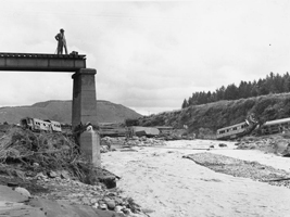
The Tangiwai Disaster
If you are travelling from Waiouru to the River Road you will pass by the Tangiwai disaster memorial. In 1953 the natural dam holding back Mt Ruapehu’s Crater Lake failed with the resulting laha taking out a rail bridge. A locomotive and the first six carriages of a passenger train ended up in the river with 151 people losing their lives in New Zealand’s worst rail accident.
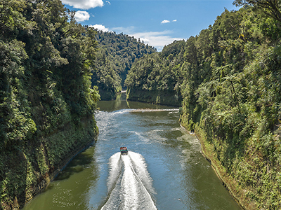
On the River Road you’ll pass through small settlements like Raetihi first, and it’s the sort of place where you can decide whether you want to turn the drive into a proper river experience—maybe a canoe/kayak trip and see the Whanganui the way it’s meant to be seen: from the water, with the cliffs and bush closing in around you. A full downriver journey toward Whanganui, the city, is still on David’s bucket list—one of those “we’ll do it one day” plans that’s been sitting there for years, just waiting for the right time.
Further along you’ll reach Pipiriki, which feels like a natural pause point—stretch the legs, take a look at the river, and see what’s on offer. If you’re up for it, you can often jump on a jet boat from here too—sometimes out to the Bridge to Nowhere—which is a great way to get a taste of the river without committing to days on the water.
You’re in a part of the country that still has a bit of “back of beyond” to it.

Canoe on the Whanganui River
Jet Boat on the Whanganui River

The Bridge to Nowhere
Whanganui is a pleasant enough little river city, with a nice waterfront, a well-presented main street, and of course the Whanganui River running right through it. For us, it’s usually been more of a “passing through” place—either on the way somewhere else, or heading home to Taranaki.

Whanganui’s Main Street

The Memorial Tower & the Whanganui River
If want to stop, the Durie Hill Elevator is one of those quirky things that’s worth doing once. You head through a short tunnel and take the underground lift up to Durie Hill, linking the town below with the lookout and residential area above. It’s a novelty, sure, but the view from the top is a pretty good reward.
And when you step out at the top, you’re right by the Durie Hill Memorial Tower. It isn’t just there for the panorama—it’s Whanganui’s official WWI memorial, opened in 1925, commemorating the 513 people from Whanganui and the district who died in the First World War.

The Memorial Tower on Durie Hill
Its biggest claim to fame, as far as we’re concerned, is the Boxing Day motorcycle road races held on the famous (and slightly infamous) Cemetery Circuit., which hosted its first races in 1951. It’s called that not because people lose their lives, but because the course literally runs through the cemetery—one of those very Kiwi ideas that sounds improbable until you see it.
Out at Castlecliff, the river mouth and beach feel like classic wild west coast: open to the Tasman, exposed to whatever the weather is doing, and with that rugged, windswept mood that the west coast does so well.

Bulls “A Town Like No Udder”
As you head further south towards Palmerston North—the largest city in the region, and where Carolyn and David went to university and met—you’ll come to the town of Bulls, where SH1 fromWaiouru and SH3 from Whanganui meet.
Bulls’ great claim to fame is being “the only place in the world where you can get milk from Bulls”, and it’s worth a quick look if you enjoy something a little out of the ordinary. Keep an eye on the signage as you pass through: many of the signs play on the word bull, and while it’s all a bit strange, it’s also hard not to smile.

Some Bulls Signage
Just after the long bridge over the Rangitīkei River, south of Bulls, you come to RNZAF Base Ōhakea. Carolyn and David have fond memories of attending several Wings and Wheels days there during their varsity years—classic and exotic cars on display, some of them racing, alongside New Zealand and visiting military aircraft, both on static display and roaring overhead in aerial demonstrations.
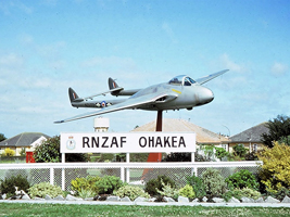
RNZAF Vampire @ Ohakea
During our time at university, Rally New Zealand brought world-class rallying to our part of the country, and each year we headed into the back blocks of the Manawatū–Whanganui Region to watch the masters of gravel at work. These were the years when rallying was shifting from the rear-wheel-drive Group 4 era, with cars such as the Opel Ascona 400, into the wild Group B period. In the 1982–1984 years, New Zealand gravel saw some of the great names of world rallying—Röhrl, Mikkola, Blomqvist, Waldegård, Alén, Salonen, Mouton and Mehta—in cars including the Audi Quattro, Lancia 037, Nissan 240RS and Toyota Celica Twin Cam Turbo. The Lancia 037 was especially significant as the last rear-wheel-drive car to win the WRC manufacturers’ title, which makes seeing that generation of cars in New Zealand feel even more special in hindsight.

Lancia Rally 037

Audi Quattro A2
In later years, the machinery became even more extreme. Rally New Zealand saw the later evolution of the Audi Quattro, along with cars such as the Peugeot 205 T16, Lancia Delta S4, Mazda RX-7 Group B and MG Metro 6R4.

Audi Sport Quattro

Lancia Delta S4
Some of those cars were driven by international stars, while others were in the hands of top New Zealand drivers, including names such as Neil Allport and Tony Teesdale. Rod Millen is another great Kiwi name from that rallying era, though his most famous international achievement came later at Pikes Peak in the USA, where he won the overall title multiple times and set a legendary gravel-era record in his Toyota Celica.

Neil Allport & his Mazda RX-7 Group B

Rod Millen and his Toyota Celia on Pikes Peak
Palmerston North is the largest city in the region and home to Massey University and the former Palmerston North Teachers’ College, now part of the university. Those institutions are what took both of us there in the first place—and it was at Massey that we met.
It’s not a city that tends to make many “must-see New Zealand” lists, but it has played a pretty big part in our own story. When we were there, it always felt like Palmerston North had a bit of a love-hate relationship with the university. The locals didn’t always seem overly fond of students or student culture, but they were much happier about the money the students brought into town. To be fair, that’s probably not unique to Palmy, but it was certainly noticeable at the time.
As a student city, it did the job: cheap flats, late nights, friends, questionable decisions, and fondly remembered early-hours expeditions to get takeaways—not because we hadn’t eaten, but because they had somehow become part of the after-party ritual as we slowly evolved into adulthood. It’s also a handy inland hub, with the Manawatū River, the Esplanade, the Riverside Pathway and the nearby Manawatū Gorge.
For us though, Palmerston North will always be less about attractions and more about that particular stage of life—leaving home, studying, meeting new people, meeting each other, pushing the boundaries, finding our limits, and slowly working out who we were becoming.

Massey University Campus

Palmerston North’s Square

Manawatu Gorge – Railway to Left, Road to Right
A couple of other locations in the Manawatū–Whanganui Region deserve a mention more in light of their impact on Kiwi culture than because of what they are as many people don’t cross over the ranges into the Tararua District where they are located.
First up is Mangatainoka, home of Tui Brewery, a place that has earned its spot in Kiwi culture. For years Tui has been known not just for the beer, but for its advertising: the famous “Yeah right” billboards, which take a cheeky swipe at politics, sport, relationships, weather, or whatever else is going on. Often blunt, funny, and very New Zealand. “Yeah Right” and “Tui” are both now part of Kiwi slang used to question whether something is going to happen or correct.

Tui Brewery
Then there was the Tui girls marketing—of its time, and probably viewed a bit differently in these overly PC times—and you’ve got a brand that became part of the national conversation as much as the beer itself.
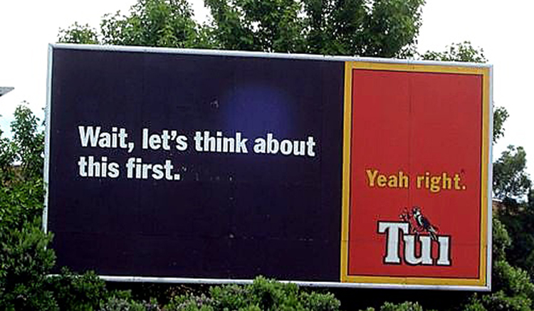
One of Tui’s less “controversial” billboards
Located nearby is Eketāhuna, a small New Zealand town that has become bigger in the national imagination than its actual size. Kiwis have long used Eketāhuna as shorthand for “the middle of nowhere”—the sort of place people jokingly refer to when they mean somewhere remote, rural, and a bit unlikely.
Closing Thought: Overall, the real standouts for us in the Manawatū–Whanganui Region are at the northern end: National Park, with Mt Ruapehu, Mt Ngauruhoe and Mt Tongariro, plus the stark beauty of the Desert Road.
Once you’re past that, there aren’t really any obvious “iconic must-sees” in the same way some other regions have.
We’ve been lucky over the years to travel more than many—though nowhere near as much as we still aspire to. The world is a big place, and there are so many destinations left to discover: places we haven’t seen yet, places we want to explore more thoroughly, and old favourites we can’t wait to reconnect with.
Elsewhere on Crows on the Go, you’ll find:
• more about our travels and the places we’ve been
• our thoughts (and, in some cases, tips) on those destinations
• the places that have become “special” to us
• and more!